Solocator - GPS Field Camera
Solocator - GPS Field Camera for precise geotagged photos, map export, and field documentation. Free now to enhance your outdoor work!
Screenshots
Download Solocator - GPS Field Camera
You are going to be redirected to the official website to finish the download when you click the button below.
About Solocator - GPS Field Camera
Solocator - GPS Field Camera is a versatile mobile app designed for professionals and outdoor enthusiasts who need accurate photo documentation with geospatial data. Available on both Android and iOS devices, this app features intuitive tools for capturing, annotating, and sharing location-tagged images efficiently. It provides an easy-to-use app experience that enhances how users document and manage their fieldwork with reliable app-based solutions tailored to photography needs.
Overview
Core Features
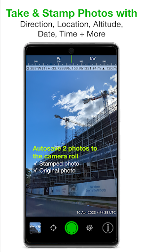
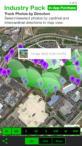
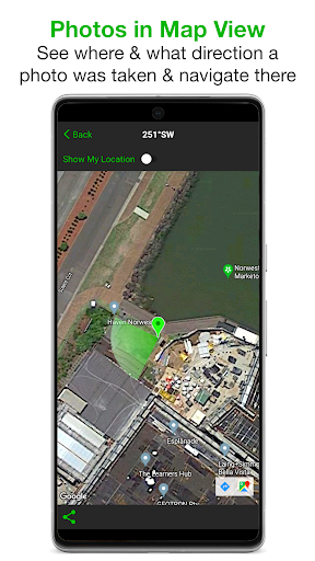
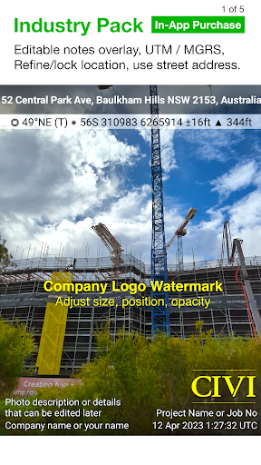
- Allows precise GPS tagging and geotagging of photos for accurate location documentation.
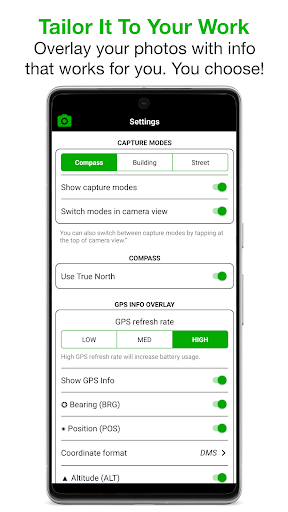
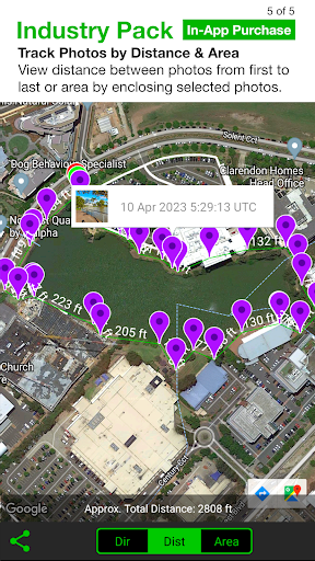
- Offers a built-in camera with distance measurement tools, ideal for fieldwork and outdoor projects.
- Includes real-time compass and angle measurement features to assist professional surveying tasks.
- Supports offline mode, enabling users to capture and store images even without internet access.
- Provides an intuitive interface that simplifies capturing high-quality photography with precise GPS data.
- Integrates seamlessly with other apps and devices, enhancing overall app experience for field professionals.
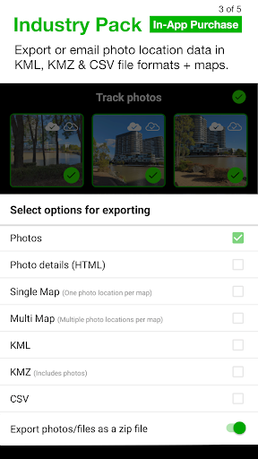
- Enables batch processing and exporting of geotagged images for efficient project management.
Who This App Is For
This mobile app is perfect for outdoor enthusiasts, surveyors, construction workers, and real estate agents who need reliable GPS-enabled photography tools. Its user-friendly design makes it accessible for users of all experience levels.
Whether you're conducting site assessments, documenting field conditions, or creating detailed reports, this app based solution provides the features you need to enhance your workflow and improve accuracy in the field.
Why Choose This App
This Android app stands out because of its combination of advanced app features and ease of use, making it a top choice for professionals and hobbyists alike. It offers a trustworthy app experience for capturing geotagged images efficiently.
Designed with real-world needs in mind, it delivers a reliable app-based solution that simplifies outdoor photography, helping users stay organized and precise in their projects, unlike many generic launcher apps or camera tools.
Features
1. User-friendly app for geotagged photo documentation
2. Accurate location overlays for professional mapping
3. Intuitive camera controls with customizable overlays
4. Easy organization, sharing, and exporting options
5. Customizable project details for tailored reports
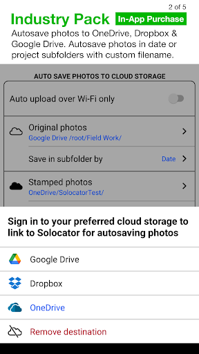
6. Seamless cloud storage integration for data safety
7. Precision GPS features for challenging environments
8. Digital field journal for comprehensive record-keeping
Pros
- +Accurate GPS positioningProvides precise geotagging for field photos, which is essential for surveying and documentation.
- +Built-in measurement toolsIncludes distance and angle measurement features, saving time during fieldwork.
- +User-friendly interfaceSimple to navigate even for new users, enhancing overall efficiency.
- +Offline map supportAllows users to access maps without internet, ideal for remote areas.
- +High-quality photo capture with GPS dataEnables seamless documentation combining images with location data.
Cons
- -Limited editing optionsBasic editing features might frustrate those needing detailed adjustments; future updates could add more tools.low
- -Battery consumption is relatively high during extended useHeavy GPS and camera usage drains battery quickly; carrying extra power banks is recommended.medium
- -Some users report occasional app crashes on certain devicesStability issues might affect workflow; restarting the app or device usually resolves this temporarily.medium
- -Map updates and synchronization may be slowOffline map data can become outdated; official updates are expected to improve this over time.low
- -Limited export formats for measurementsExport options are somewhat restricted; future versions may include more formats to enhance compatibility.low
FAQ
Is Solocator - GPS Field Camera easy to use for beginners?
Yes, Solocator is designed with a user-friendly interface, making it accessible even for beginners. Its straightforward layout ensures that users can quickly learn how to operate the app and utilize its main features.
Many find that the app experience is smooth and intuitive, helping you capture precise GPS-tagged photos effortlessly while on the field or in specific project situations. It's a reliable mobile app for professional and amateur photographers alike.
Can I use Solocator on my Android device without any issues?
Absolutely. Solocator is available as an Android app, and it works seamlessly on most Android devices. The app features are optimized for a variety of screen sizes and Android versions, ensuring a consistent app experience across devices.
Including in-depth app features like GPS location tagging and measurement tools, this app based solution is trusted by professionals for its accuracy and reliability on Android mobile devices.
Does Solocator require an internet connection to function properly?
No, you don't need an internet connection for most of its core app features. The app is built for offline use, making it ideal for fieldwork where connectivity might be limited. GPS tagging, measuring distances, and capturing photos work independently of an active internet connection.
This app experience is designed to be dependable in various environments, offering a practical app based solution for field professionals who need precise location data without connectivity concerns.
Is Solocator safe to install and use?
Yes, Solocator is a safe and trusted mobile app. It's developed by reputable creators and is available on official app stores like Google Play and the Apple App Store, ensuring it's free from harmful software.
Additionally, the app respects user privacy and only uses necessary permissions such as camera and GPS. Its safety and reliability are part of its strong app experience, making it suitable for professionals and enthusiasts alike.
What are some key app features of Solocator - GPS Field Camera?
Solocator's main features include GPS-tagged photo capture, measurement tools for distances and angles, and the ability to add annotations directly on images. It offers a professional app experience tailored for fieldwork and shooting in demanding environments.
This app based solution provides accurate location data and high-quality image capture, making it a popular choice among surveyors, architects, and outdoor enthusiasts seeking a reliable mobile app for their projects.